
Open source GPS for RC sailboat: all features explained
- FRA222

- 4 hours ago
- 4 min read
An onboard GPS module, open source, to analyze and optimize the trajectory and settings of your RC boat
1 - Why use a GPS on our radio-controlled sailboats?
We are curious to know whether using a GPS on our radio-controlled boats during training can help us in our pursuit of performance.
We can imagine that by measuring the boat's speed and heading, and comparing them to the wind speed and direction, we will be able to improve our sail trimming and better understand the boat's behavior.
To achieve this, we have designed and developed an onboard GPS system, open source, to measure and visualize navigation data in real time and after the session.
2 - What are the features of the GPS and the display?
The system relies on two complementary components: the GPS module embedded on the boat, and the display unit mounted on the radio controller. A wireless transmission solution connects the two and makes it possible to retrieve, display in real time, and store GPS information on a microSD card during sailing. This recorded data can be used afterwards to review the navigation session.
The GPS module embedded on the boat


Measures the boat's speed and heading
The GPS module measures the boat's speed and heading and transmits this data once per second in "broadcast" mode using the ESP-Now protocol, similar to Wi-Fi.
A lightweight hatch, barely heavier than the original, 3D-printed in translucent PETG filament
The GPS module is integrated into a hatch that replaces the boat's original cover. The whole assembly remains very light: the GPS-equipped hatch weighs only 54 g more than the standard hatch, an almost negligible extra weight for sailing.
The new hatch is printed in translucent HF PETG for:
Resistance to water and heat up to 80°C
To allow visibility of the color LEDs, both for the battery and for the GPS module
A color LED to indicate battery status:
Yellow LED: battery charging
Green LED: battery fully charged
Red LED: battery discharged. The module protects against excessive discharge.
A color LED to indicate GPS module status:
Red LED: module starting up
Yellow LED: GPS connection in progress. If needed, place the module outdoors.
Green LED: GPS connection active and data transmission active.
Customized for your boat
The boat number is configured directly in the module. Both the data recording and the real-time display then use this number in the format "FRA 121" or "USA 342", making it always clear which boat the data comes from.
Completely autonomous
The module is completely autonomous: it has its own battery and integrated charger, rechargeable via a standard micro-USB port. No connection to the boat's electronics is required.

Magnetic switch activation
The GPS is turned on and off using a magnetic switch located on the outside of the module. No need to remove the module to switch it on or off — and, since the case stays permanently closed, there is no risk of water getting inside.
The display on the radio controller
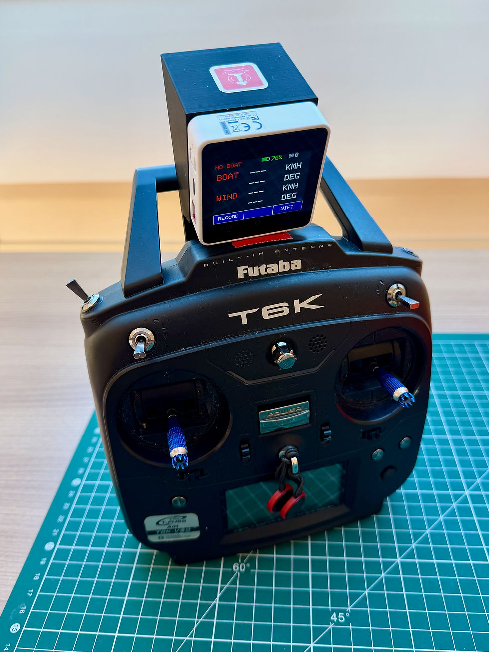
Les données GPS affichées en temps réel sur l’écran fixé à la radiocommande.
GPS data displayed in real time on the screen mounted on the radio controller.
Heading and speed in real time
The boat's speed and heading are displayed in real time on the screen positioned above the radio controller.
Recording on microSD card
This same information is recorded on a microSD card inserted in the display unit. Recording is controlled directly from the touchscreen (button at the bottom left): you can thus keep only the interesting periods and avoid having to analyze several hours of sailing data at the end of the day.
Wind speed and direction
The display is not limited to the boat's data. Paired with the anemometer installed on a buoy, it shows the wind speed in real time. The wind direction, also retrieved via the buoys, is also displayed in real time.
Tracking multiple boats
When several boats are sailing at the same time, they all send their data in real time to the display. The display records everything on the microSD card and shows the selected boat: simply press the middle button on the touchscreen to cycle through the boats in rotation. By displaying each boat's name, you can immediately identify which boat you are looking at, both live and during post-session analysis.
Transmission range
The main limitation of the system is the data transmission between the boat and the display. Communication is done via Wi-Fi: the range is good up to about 80 meters, then degrades beyond that — which remains sufficient in most situations. It is also a simplified Wi-Fi that reconnects immediately: in the event of an obstacle or excessive distance, a few data points may be momentarily missed, but the system recovers on its own. If necessary, it is also possible to add a "repeater" on an intermediate buoy to extend the range.
To go further, I recommend reading the article dedicated to the speed display: you will understand where and how the different data is centralized.
3 - Where to find this boat GPS?
This device, still experimental, is made available to the community as Open Source on GitHub, in the OpenSailingRC-BoatGPS repository.
You will find four important documents on the site:
- The list of materials to purchase on the M5Stack website for both the GPS and the display. Please use the affiliate links if possible — it costs you nothing extra, and it helps us develop new products.
- Assembly instructions for the GPS and the display
To integrate the GPS into your boat, you can either design the solution yourself — adapted to your specific boat — or use, if you have a df95, the 3D model we created, which includes a magnetic switch. For the df95, the GPS module has been designed to fit into the boat's hatch, replacing the original cover. Installation is thus straightforward and perfectly suited to the existing structure. You can purchase the .stl 3D file, along with its printing instructions, to print it yourself for a very modest price.
If you need help with a custom design for a specific boat, feel free to contact us.


Comments